History & story.
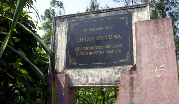
Chau Sa Citadel was built around the 10th century during the Cham Pa kingdom's most flourishing era along the central Vietnamese coast. It served as an administrative and military fortress on the banks of the Tra Khuc River, controlling the vital communication route between the coastal plains and the inland highlands. The Cham engineers used rammed-earth techniques to raise walls 4–5 metres high over a perimeter of approximately 4 kilometres — a massive earthwork requiring neither fired brick nor dressed stone. The citadel's plan is nearly square, with the four corners reinforced by thicker wall sections to better withstand attack and structural loading. Chau Sa remained operational from the 10th through the 15th century, as the Cham Pa kingdom gradually contracted before the Dai Viet southward expansion.
Throughout its five centuries of existence, Chau Sa Citadel witnessed many important historical events in the Quang Ngai region. In the 14th and 15th centuries, as Cham Pa and Dai Viet engaged in repeated military conflict, Chau Sa became a critical defensive outpost controlling the Tra Khuc River basin. After the territory was absorbed into Dai Viet under the early Le dynasty in the 15th century, the citadel was gradually abandoned and its earthen walls were slowly reclaimed by time and vegetation. Vietnamese archaeologists conducted multiple excavation campaigns from the 1990s onward, uncovering characteristic Cham ceramics — jars, bowls, and urns — alongside tools and everyday domestic objects. These artefacts are now displayed at the Quang Ngai Provincial Museum, offering a direct window into civilian life inside the ancient walls.
The rammed-earth architecture of Chau Sa reflects a construction technique very different from the famous brick Cham towers elsewhere in central Vietnam. While the brick towers were built for religious worship and to express divine power, Chau Sa is an entirely secular structure — designed purely for military defence and administrative control. The earthen walls have a base width of 8–10 metres, creating a broad patrol walkway along the top. Inside the citadel, traces of wooden structures survive — dwellings, granaries, and barracks — but only earthen floors and a few rotted post-holes remain visible in excavation trenches. The surrounding landscape of rice paddies and coconut palms lends the site a peaceful quality that makes it hard to believe this was once the most formidable military fortress the Cham Pa ever built in Quang Ngai.

Today, Chau Sa Citadel is designated a National Historical Monument and is one of the few surviving Cham Pa earthen fortifications in central Vietnam to remain relatively intact. The site is freely accessible with no admission charge, and visitors can walk along surviving wall sections to appreciate the sheer scale of the construction. During the dry season from November to April, the grass covering the earthen walls turns golden, creating a steppe-like landscape strikingly out of place amid the surrounding green paddies. The Quang Ngai Department of Culture is implementing a restoration and heritage promotion project from 2025 to 2030, with plans to build an artefact display hall and reconstruct a section of the wall using traditional Cham rammed-earth techniques.
Earth builds the walls, people build the nation — the walls may fall, but the nation and its people endure.
Câu nói dân gian Quảng Ngãi, được cho là từ truyền thống Chăm Pa
Highlights not to miss.
The Cham rammed-earth technique (đắp đất nện) produces walls with a lifespan of thousands of years using no binding materials beyond earth and water. A base width of 8–10 metres ensures absolute stability even under sustained attack. This is one of the few Cham earthen fortifications to survive into the 21st century intact, a living document of the civil engineering skills of a vanished civilisation.
Multiple archaeological campaigns since the 1990s have uncovered hundreds of characteristic Cham ceramic shards with intricate geometric patterns and the reddish-brown glaze characteristic of Cham Pa ceramics. Alongside the ceramics are iron tools, glass beads, and grinding stones — evidence of a substantial civilian community once living within the walls. Artefacts displayed at the Quang Ngai Provincial Museum help visitors visualise the daily life of Cham Pa inhabitants at Chau Sa.
Chau Sa Citadel sits amid the flat rice paddies of Son Tinh district, its earthen walls rising like gentle ripples across the floodplain. During the dry season from November to April, the grass covering the walls turns golden, creating a strikingly different colour against the surrounding green. The sunset view from the top of the walls across the Quang Ngai plain, with the Truong Son mountain range visible to the west, is one of the province's most beautiful and least-known vantage points.
Visit Chau Sa in December–February when the grass on the earthen walls turns golden-brown, contrasting sharply with the surrounding green rice paddies. This is the best time for landscape photography and the driest period of the year.
How to visit & get there.
Getting to Chau Sa Citadel **From Quang Ngai city**, take National Highway 24 northward for about 8 km, then turn left into Tinh Chau commune following the heritage site signs. **Motorbike** is the most convenient option; **cars** can park in the open lot near the entrance. No public buses run directly to the site.
Making the Most of Your Visit **Wear walking shoes** — you will need to climb the earthen walls and walk along surviving sections. **Early morning** (6:00–8:00 AM) gives the best light for photography and avoids midday heat. **Combine with the provincial museum**: visit the Quang Ngai Museum first to see excavated artefacts, then come to Chau Sa in person for a much richer understanding of the site.
Sources
- 1.Thành cổ Châu Sa — dấu tích Chăm Pa Quảng Ngãi
Tạp chí Tổ Quốc · 2026-06-26
- 2.Thành cổ Châu Sa — di tích lịch sử Quảng Ngãi
VietnamPlus · 2026-06-26